
Trip Plan
Maps and Guidebook:
The 5-map set of Catskill Trails published by NY-NJ Trail Conference.
The third edition of Catskill Trails published by Adirondack Mountain Club.
Trails traversed: BD, BM (?), ES (?), BK
BD (red): Black Dome Range Trail
BM (yellow) Blackhead Mountain Trail:
ES (blue) Escarpment Trail:
BK (yellow): Batavia Kill Trail
The First Day (01/28/2006)
Route: (Map41, N2 and O2)
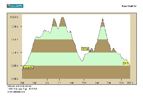
Start early from the parking lot at the end of Barnum Rd (0.9 mile from the W trailhead of BD).
Head east on BD, summit Thomas Cole (3940), and Black Dome (3980).
Pass the trail junction of BD and BM, continue on BD.
Turn right onto BK, reach the lean-to after 0.65 miles.
General description and features:
From the starting point to the Thomas Cole Mt, it’s a steady climb. We then drop to the col between Thomas Cole and Black Dome and start to climb again. The challenging part for the first day will be the descent from Black Dome to the point where we reach 3000-foot.
We will have great views of many high peaks in the Catskills, including the 6 peaks on the Devil’s Path, Slide, Table, Rust and more.
Mileage and Elevation change:
The total mileage is about 6.4 miles, and the elevation change is 2250+/1800-.
Camping:
A lean-to on BK, 0.65 miles from BD and 0.25 mile from ES.
Water:
No water source for drinking water for the first 5 miles.
Water available at the lean-to.
The Second Day (01/29/2006)
Route: (Map41, O2)
Do a turn-around trip to summit Blackhead (3940). After we return to the lean-to, we will hike out to the parking lot at the east end of Big Hollow Road.
Two possible approaches to summit Blackhead:
1. From the lean-to, head east and turn right onto ES. Total mileage (round-trip): 3 mile.
2. From the lean-to, head west and turn left onto BD, and turn left onto BM. Total mileage (round-trip): 6 miles.
Note: Although the Option 2 is twice as long as Option 1, the terrain is less steep. We will decide which route to take on Sat night depending on the condition.
From the lean-to to the parking lot, we hike on BK and turn right onto BD. It’s an easy hike, and the distance is 1.25 miles.
Features:
Still, great views of numerous high peaks in the Catskills. Also, we bag the Blackhead Mt.
Elevation gain to the Blackhead: about 1800+.
Condition:
It’s difficult to say at this point. I’ve been following some discussion from the 3500-club mailing list. It seems that right now the trail is pretty wet, some trails are icy and full crampons are required. Be sure to bring your snowshoes, crampons, and poles along. And let’s cross our fingers for snow!
To participate:
Please send me an email. I’ll have to ask you to fill out a screening form. And after you’re approved to join this backpack, I’ll email you a complete write-up regarding meeting schedule and driving directions, etc.
Pingback: Final Frontier: An Outdoor Blog » Blog Archive » Planning a Trip如何ç–劃戶外活動
Pingback: Final Frontier: An Outdoor Blog » Blog Archive » Trip Journal – Blackhead Range Backpack行程記錄 – Blackhead Range Backpack